吉野川 Yosino-gawa The Yoshino River
|

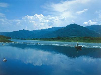
The Yoshino River (also known as Shikoku Saburo) is the mainstream of the Yoshino Riverine System, originating from springs located in Kamegamori (elevation 1,896m), which bears its peak near the town of Saijou, in Ehime Prefecture. The limpid river cuts across Kouchi Prefecture and joins the Kii Waterway in Tokushima City. Stretching across 194km and with a watershed of 3,750 km² it is one of Japan’s three rivers most likely to break into torrents. It is often said that the flow of the river represents the heart and emotions of the citizens of Tokushima. Since the river relates to Kouchi, Ehime and Tokushima prefectures, it was once called the Midochi (Three Lands) River. In the lower reach of the river where the river is wedged between the Sanuki Mountain Range and the Shikoku Mountain Range, are the Tokushima Plains. Where the river traverses through the Shikoku Mountain Range is a perfect example of an antecedent valley in Japan, and is home to many scenic spots such as Ooboke and Koboke. The reason for the nickname Shikoku Saburo is because of an old saying, “it is a river whose reeds grow thick on its banks”. Although it is true that this river, which snakes through four prefectures, has a notorious history of flood disaster, it also has brought many blessings, acting as a life line for the people who live by it.

- name
- Yoshino River